October 7 Interactive Map
Product design for a map based exploration experience

Product Design · National Library of Israel
2026
The challenege
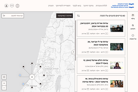
The National Library of Israel is preserving a large and diverse collection documenting October 7. Many of its materials are connected to specific places, and bringing them together on a map can reveal the geographic context of the events they document. The challenge was to turn these connections between place and content into an intuitive way to explore the collection and understand what happened across different locations.

NLI’s homepage, highlighting the Library’s ongoing effort to collect and preserve materials documenting October 7.
The objective
To create an intuitive map based experience that helps users understand the events in their geographic context, while encouraging them to explore the collection and discover related materials through the map.


The process
I worked closely with the product manager to translate the product vision, available data and technical constraints into an intuitive geographic exploration experience.
01 ·
Understanding map patterns
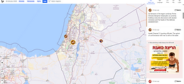
I started by reviewing a range of map based experiences to understand common patterns for combining geographic exploration with contextual information. I looked at how different products approached navigation, information panels, map controls, pins and clusters, and used what I learned to shape an experience that fit the specific needs of the collection.




02 ·
Mapping the information landscape
The experience brings together four entity types: items, places, people and topics. Each has different information, capabilities and relationships to the map. I mapped these differences, along with the actions and content available in different contexts, to define an information architecture that could support them within one coherent experience. A single entity can include multiple types of information and actions within the same structure.
Multiple states within a single entity

Default · Related items

Filter

Sort

Overview
03 ·
Defining the interaction model
The map was designed as the primary way to discover and navigate the collection. I kept it as the main surface and used a persistent side drawer for contextual information. The drawer can be collapsed to give more space back to the map while preserving the selected context.

Open

Collapsed
Defining pin behavior
I defined a consistent interaction system for pins and clusters across the map. Clusters share the same default appearance, but their behavior adapts to the type of overlap. Technical clusters zoom in to reveal nearby pins, while fixed clusters provide additional context on hover and expand pins that share the exact same coordinates. Individual pin states allow users to explore other pins while keeping the current selection connected to the information shown in the drawer.
Cluster behavior
Technical cluster

Default

Hover

Open · Zoom in
Fixed cluster

Default

Hover
Open · Expands overlapping pins
04 ·
Adapting the model for smaller screens
On smaller screens, the side drawer becomes a bottom panel, allowing the map and content to share the limited screen space. Its different states let users control how much screen space is dedicated to the selected content while keeping geographic context visible.
Individual pin interaction

Selected

Hover while selected

Default · Shows title and key information

Collapsed · Keeps navigation and title visible

Expanded · Enables scrolling through the full content
05 ·
Creating one system for different content types
I created a shared structure for presenting different entity types, with consistent headers, information hierarchy and interaction patterns. Built on NLI’s design system, the interface was adapted to the map’s specific needs while allowing each entity type to retain the content and actions relevant to it.

Item

Person

Place

Topic
Finding the right level of distinction
Color needed to help distinguish between entity types while working consistently across their different information structures. It also had to support the information hierarchy and remain appropriate for the sensitive subject matter. I explored different ways of applying color across headers and navigation, eventually moving toward a more restrained system that uses color alongside labels and icons without competing with the content.
Place


Item


Selected explorations
Final design

Item

Place

Person

Topic
The outcome
As the National Library of Israel preserves the cultural memory of October 7, the map brings together different forms of documentation connected to people, places and topics. Connecting these materials through geography creates a broader picture of what is being preserved and allows users to explore it in its geographic context. Designing the experience meant balancing the complexity of the collection with the sensitivity of materials that will become part of the Library’s long term cultural record. The map launched in October 2026 and is now live on the National Library of Israel’s website, giving the public and researchers a new way to explore the collection through its geographic connections.